Warm Sector, Cold Truth: Atlanta's 28°F Crash and What Polymarket Missed
The March 2026 megastorm delivered the sharpest temperature swing in the US this winter. We tracked how Polymarket's daily weather markets priced — and mostly failed to anticipate — Atlanta's 28°F temperature collapse in 72 hours.
Warm Sector, Cold Truth: Atlanta's 28°F Crash and What Polymarket Missed
The week of March 13–17, 2026 was one of the most meteorologically chaotic stretches of weather in recent US history. A massive extratropical cyclone — already being called the "March Megastorm" — carved through the country, delivering a record blizzard to the Great Lakes, a tornado outbreak across the Mid-Atlantic, and catastrophic flooding in Hawaii, all simultaneously.
But buried inside that chaos was a quieter story: what happened to daily high temperatures in Atlanta. And Polymarket's daily weather bracket markets had a front-row seat.
The Setup: Atlanta Was Cooking Before the Crash
In the days leading into the storm, Atlanta was riding a prolonged warm-sector surge. The warm air mass ahead of the incoming cold front pushed daily highs well above seasonal norms. On March 11, Atlanta hit 80–81°F — more than 15°F above its average March high.
The pattern held through March 14, when the city peaked at 76–77°F as the storm's warm sector lingered. Polymarket's temperature bracket markets reflected this confidence: the "≥72°F on March 15" YES token was trading at 79–91% probability throughout March 13 and 14. The market had correctly read the warm-sector signal.
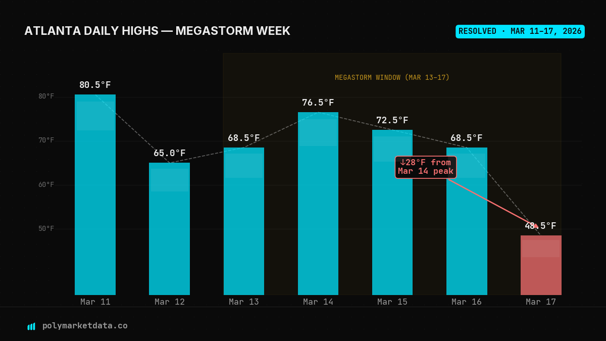
Atlanta resolved daily high temperatures from Polymarket's bracket markets. March 11–15 reflects the storm's warm sector; March 17 shows the cold-front crash.
Then the cold front came through.
March 17: The Floor Drops Out
By March 17, Atlanta's daily high had collapsed to 48–49°F — a 28°F plunge from the peak just 72 hours earlier. Wind chills pushed it colder. The same warm air that had been hugging the Southeast was replaced overnight by a hard Canadian airmass riding south behind the storm's cold conveyor belt.
For context: Atlanta's average March 17 daily high is roughly 65°F. A reading of 48–49°F is roughly 2.5 standard deviations below normal for this time of year. Not unheard of — but sudden.
NYC tells a similar story. On March 12, New York hit 56–57°F. The very next day, March 13, the storm's cold slot slammed into the Northeast, and the city's high dropped to just 42–43°F — a 14°F overnight swing. The following days oscillated between 46–47°F and 54–55°F as the system dragged through.
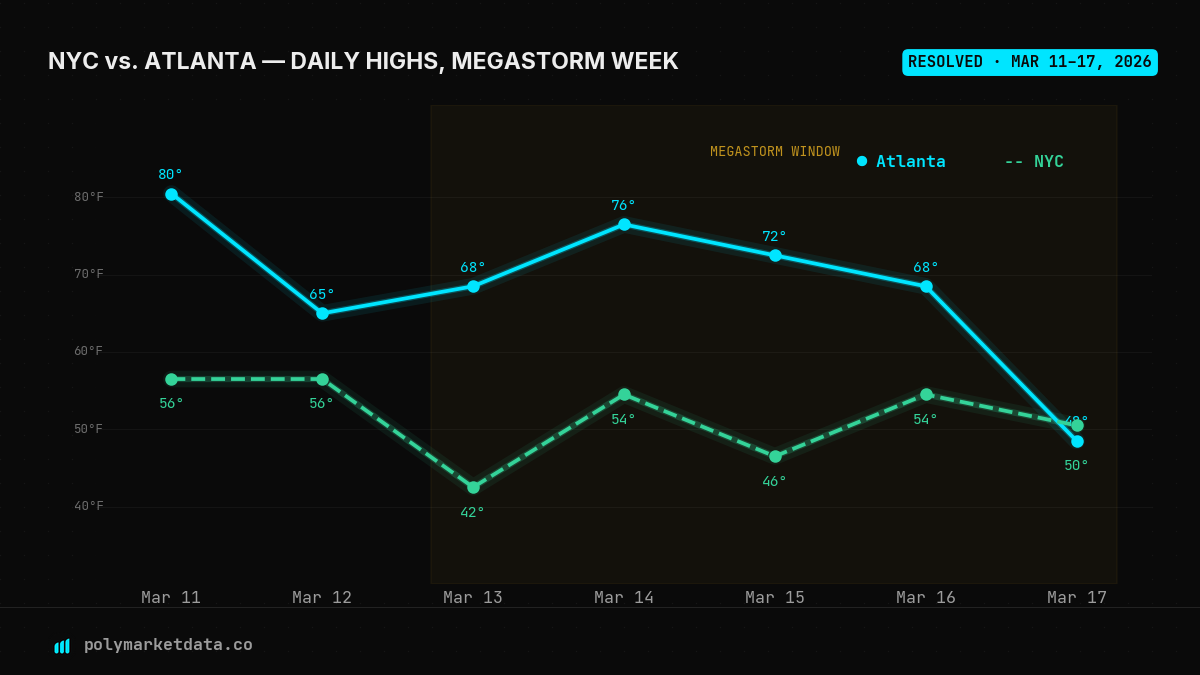
NYC and Atlanta daily highs compared. Atlanta's swing is more dramatic, peaking higher and crashing harder. NYC shows the earlier cold-front signal.
Where the Market Got Caught Flat-Footed
Here's where it gets interesting.
Polymarket's daily weather markets on Atlanta use a bracket structure: each day has 9–11 separate YES/NO markets, each covering a 2°F temperature range (e.g., "Will Atlanta's high be 48–49°F on March 17?"). The token prices act as a real-time probability distribution across all possible outcomes.
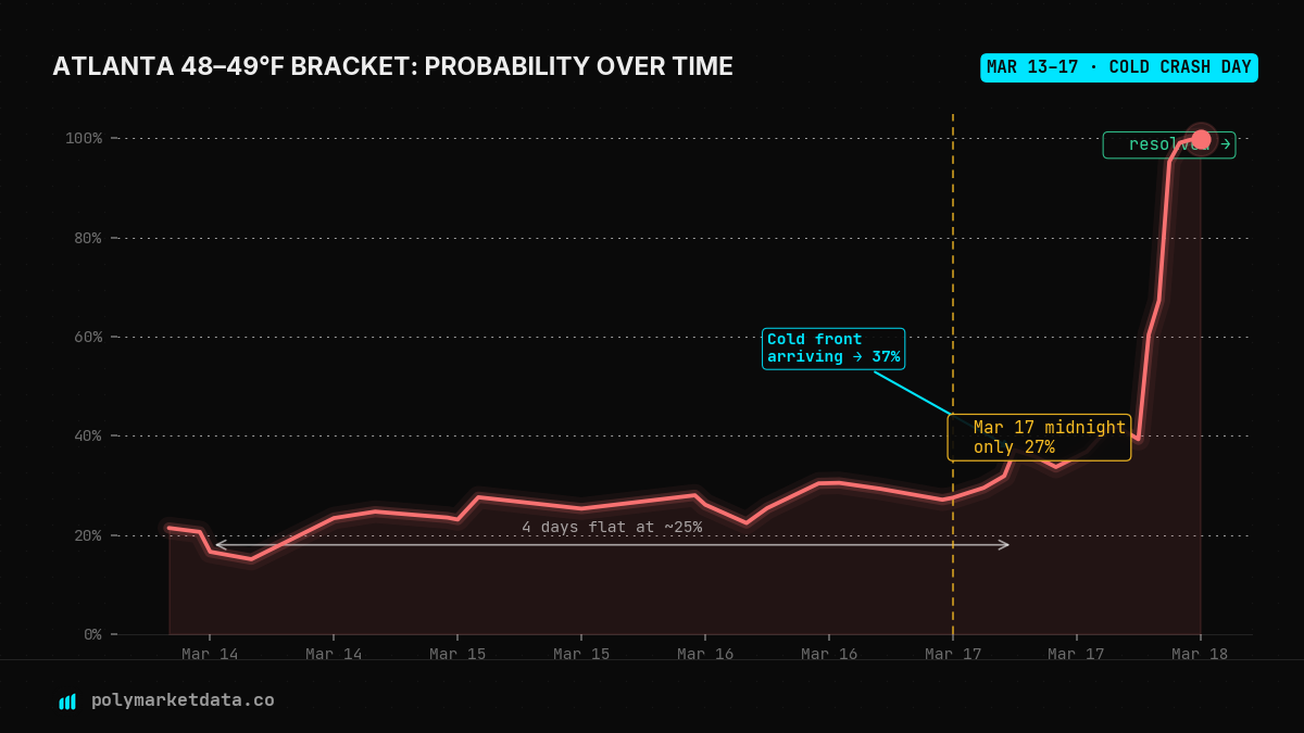
We tracked the YES token for "Atlanta 48–49°F on March 17" from the moment it was active through resolution.
The story is striking:
- March 13–16: The bracket sat at 20–30% probability — the market assigned roughly 1-in-4 odds to the cold outcome, consistent with the full range of uncertainty across a week-out forecast.
- March 17 midnight: Still only 27%. The market was not pricing a surprise.
- March 17, 6am: The first real signal — probability jumped to 37% as overnight forecast model updates started integrating the cold-front timing.
- March 17, 4pm: 42% — the front was arriving, but still not confirmed.
- March 17, 7pm: 60% — likely reflecting the afternoon high reading coming in cold.
- March 17, 9pm: 95% — locked in.
- Resolution: 99.8%
Polymarket's "Atlanta 48–49°F on March 17" YES token probability from March 13 to resolution. The market sat flat at ~25% for four full days, then converged in the final hours.
What This Tells Us
A few things stand out from this data.
1. Weather markets are NWP-followers, not leading indicators.
Modern numerical weather prediction (NWP) models — GFS, ECMWF — are what drive the smart-money price signal in these markets. The bracket probabilities closely tracked the spread of model ensemble outputs rather than any independent information source. This is efficient in normal conditions, but it means markets move when models move — not before.
2. Cold-sector surprises are systematically underpriced.
There's a documented forecasting asymmetry in synoptic meteorology: warm sectors are easier to forecast than cold sectors during rapidly developing mid-latitude cyclones. The timing and depth of cold-frontal passage is notoriously sensitive to small changes in jet stream positioning. Polymarket's markets appear to inherit this forecasting bias — warm outcomes were better-priced earlier, while the cold-sector resolution came only as physical confirmation arrived.
3. The 72-hour window is where the edge lives.
The "48–49°F" bracket had essentially no price signal until roughly 18 hours before resolution. For a 28°F temperature swing, that's a remarkably late convergence. A trader with access to high-resolution mesoscale models — or even just good situational meteorological awareness — could have found value on the cold brackets for Atlanta in the 12–24 hours preceding March 17 at 25–30¢.
The Bigger Picture: La Niña Exits, Volatility Enters
This megastorm arrived at a particular moment in the climate cycle. La Niña — which had been suppressing US winter volatility by keeping the polar jet displaced northward — exited faster than expected in early March. NOAA now puts 62% odds on El Niño developing by June–August 2026, potentially emerging as a significant event.
El Niño characteristically amplifies mid-latitude weather volatility, particularly in the transition seasons (spring, fall). If that pattern holds, March 2026 may be a preview rather than an outlier: rapid temperature swings, compound storm events, and weather markets that struggle to price sudden regime changes until they're already happening.
Polymarket's daily weather bracket markets across NYC, Atlanta, Miami, Chicago, and a dozen other cities represent a continuous, real-money forecast on short-range temperature outcomes. As weather volatility increases, so does the potential for genuine mispricing — and the edge for traders who can read the signals.
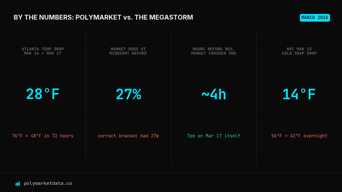
Key numbers from the week. The market had only 4 hours before resolution to price the 28°F crash above 50% probability.
Data sourced from polymarketdata.co — historical Polymarket prices, order books, and metrics for traders and researchers. All temperature bracket resolutions confirmed from Polymarket's on-chain settlement data.